


Geo Area
Geo Area açıklaması
GEO AREA is used by the industry for a long time. Geo Area is born in the agriculture fields, in Urban Planning sessions, and in remote sensing projects. It is designed to cater for just about anyone's needs to measure field areas, collect ground samples, GIS surveys, and measuring perimeter shareable on all GIS platforms.
WHAT MAKES GEO AREA UNIQUE?
- Highly accurate area measurement, verified and tested with ground data
- Multiple area and perimeter units
- Ability to generate KML files
- Sharing KML for visualization on any GIS
- Ability to edit, delete records
- User friendly
- Intuitive interface based on latest Android Material design
- Tap the map to mark area, OR
- Use the phone GPS receiver
- Ability to pause, start and stop GPS mode so that you can easily select the desired points
- Unlike our competitor Apps, Geo Area has NO RESTRICTIONS ON SHARING your data
- Not just an area calculator, its much more
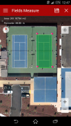
ACCURACY TEST EXAMPLE:
One of the screenshots shows Google Tennis Courts at (1600 Amphitheatre Pkwy,Mountain View, CA 94043) - check this yourself to see how accurately Geo Area works:
Tennis court dimensions are: 36 ft(10.97m) x 78 ft(23.78m)
Therefore, Area= 36 ft(10.97m) x 78 ft(23.78m)=2808 square feet(260.8666 square metres)
Perimeter = Sum of all four sides=228 ft (69.5m)
You can change units from the application settings from feet to meters OR to acres OR to hectares OR to kanals OR to kilometers. Your choice!
GEO AREA LETS YOU DO THE FOLLOWING:
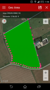
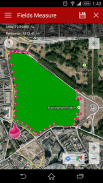
1. Measure the area and perimeter of just about anything on the ground as seen on Google Maps
2. Use area and perimeter units of your choice including feet, meter, hectare, Kanal (area units for India), kilometer, yards, and acre.
3. Either tap on the points of interest on the Google Maps to mark area, OR
4. Use the phone's GPS to mark the field boundary
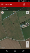
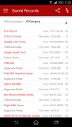
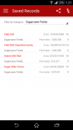
5. Create Categories of your choice where you can group fields,please refer to the screenshots
6. Create unlimited categories
7. Geo Area lets you share and see the marked fields on any GIS for instance the Google Earth
GEO AREA is for:
1. Land based surveys
2. Farmers, for farm management
3. Land record management
4. Construction surveys
5. Agronomists
6. Town planners
7. Construction surveyor
8. GIS data collection
9. Health, Education and facilities mapping
10. Farm fencing
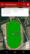
11. Sports track measurement
12. Construction sites and building sites area
13. Asset mapping
14. Landscape artists
15. Landscape design
Geo Area is used by farmers for several agricultural applications: crop yield estimation, crop area measurement, and agriculture yield. Geo Area has been used in conjunction with remote sensing (satellite imagery e.g. SPOT 6, SPOT 7) and GIS applications, to collect ground truth data, field records, crop yield, farmers data and agriculture output. Geo Area is ideal for land cover analysis, vegetation mapping and remote sensing where Regions of interests (ROIs) or the Points of Interest (POIs) or Area of Interest (AOI) collected through Geo Area. As seen in the example, Geo Area is ideal for area measurement (area calculator) and perimeter of sports grounds, cricket grounds, football pitches, tennis courts, badminton courts, parking lot area, residential space, running track and rental space. Several other applications exist e.g. transforming manual Patwari or Patvari and the old tape measure system for land record management.
Geo Area is customizeable for all crops including cotton, wheat, rice, sugarcane, sugar beet, maize, tobacco, Virginia, FCV tobacco, vegetables, banana plantations, dates and orchards mapping. Geo Area has also been used for forest mapping and GPS based measurement of deforestation area. Geo Area has also been used to estimate fertilizers, chemical spray, insecticides required for agricultural fields based on the calculated area.
Nothing is complete in itself - we are learning from YOU to make Geo Area more useful. Thank you for your comments and feedback.
</br></br></br></br></br></br></br></br></br></br></br></br></br></br>
</br>
</br></br></br></br></br></br>
</br>
</br></br>
</br>
</br></br></br></br></br></br></br></br></br></br></br>
</br>
Geo Area - Sürüm 1.6
(04-11-2016)Geo Area - APK Bilgisi
APK sürümü: 1.6Paket: com.cegmas.geoareaGeo Area uygulamasının en son sürümü
Diğer sürümler


Aynı kategorideki uygulamalar

Hoşuna gidebilecekler...


